
So let's jump right into the action with my very first posted GoPro video! I mounted the GoPro Hero Session camera on the handlebars of my Brompton bicycle and then edited it in GoPro Studio.
And now for the details of this great ride...
I woke up at 4:15 AM on Saturday morning, and by 5:00 AM I had my Brompton, helmet, Brompton bag, and supplies packed away my rented ZipCar, ready to go. I stopped at my local Dunkin' Donuts for my morning coffee...

...and then headed west!
Around 2.5 hours later I arrived at Look Park in Florence, Massachusetts -- a good starting place for riding the Mass. Central Rail Trail, which turns into the Norwottuck Rail Trail in neighboring Northampton.
This area is known as the Five College region, named after University of Massachusetts-Amherst, Smith College, Mount Holyoke College, Amherst College, and Hampshire College. Far away from any big cities and anchored by the towns of Northampton and Amherst, this a land of rolling hills, farms, and villages. And much of it is now connected by bike paths and bike lanes.
Here's where I joined the Mass. Central Rail Trail at Look Park:


In Northampton I rode by the old train station (now a restaurant)...

...made my way down a quiet side street (lovely sunflowers)..,

and then joined the Norwottuck Rail Trail, which runs from Northampton, through Hadley and Amherst, and ends on a rural road by the swamps outside Belchertown.
The rail trail follows the route of old the train tracks that used to run from Northampton all the way to Cambridge, Massachusetts. Passenger service ended in the 1930's, partly because of damage sustained during the Hurricane of 1938.
The Norwottuck begins with a grand start, as you cross the old railroad bridge that spans the mighty Connecticut River.


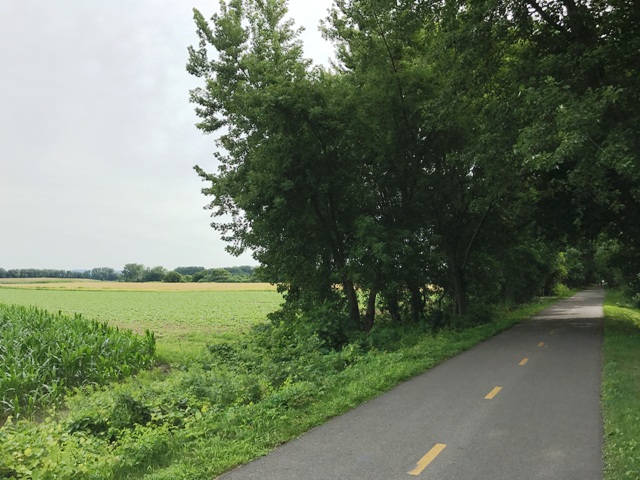
From there the path heads east through peaceful farmland.


The photo below is of a place I stopped for a good long while, watching the tree swallows dart about catching flies. They're tough to photograph, but you can see two of them zipping by in this picture (I just realized that I missed a great GoPro video opportunity! Oh well, next time!):

All along the path were places where the trail branched off and led to streets taking you into the towns along the route, like Hadley and Amherst. I decided on this trip to stay on the main path and then check out some of the towns on the drive back home. I've learned from past rides that it's usually a good idea to set these kinds of priorities in advance, otherwise you try to see too much, get exhausted, and can't fully enjoy all you experience.
The most magical part of the Norwottuck Path lies just beyond Amherst, where it enters the swamps of the Brickyard Conservation area.


At the risk of getting over-dramatic here, I must say that standing in this spot really affected me deeply. It was so quiet, with nothing but the sounds of birds, critters, the wind, and the cyclists and walkers on the path. Living in an urban area, I'd forgotten how quiet the natural world can be. Although I saw very few birds (I was hoping to jot down more sightings in the front cover of my Peterson's Field Guide to Birds of North America book!), I could certainly hear them, and I imagined so many little animals call this beautiful swamp home.
On my return trip, I passed by this sign:
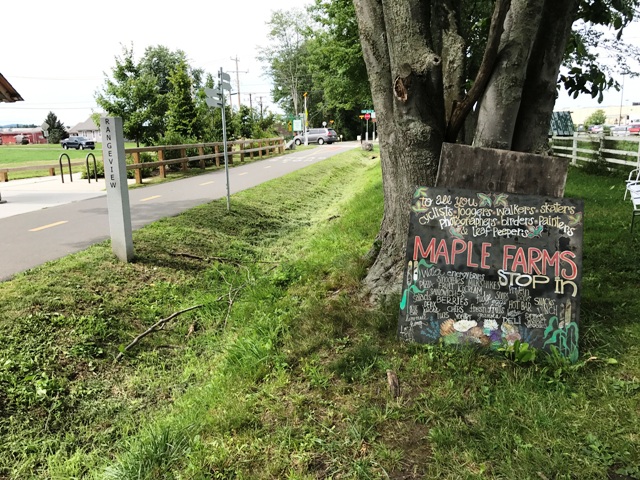
So of course I had to stop in to get a bite to eat! I purchased some very good cornbread.


This is a good time to add that the Brompton rode like a dream on this trip. It's so remarkably comfortable, even over long miles.
Arriving back at my ZipCar....

I decided to explore Look Park a bit. It's such a cool place! There's a little narrow gauge railroad for kids, paddle boats, picnic areas, and beautiful landscaping. I must come back another day and explore this park further.

For my drive home, I decided to take local Route 9 for most of the way back to Boston, rather than the Mass. Pike. In doing so, I made a remarkable discovery...
Although I drove back through the lovely villages and farmland that I saw from the bike path, I also drove through vast areas full of fast food restaurants, malls, and big box stores -- all of which I could tell from Googlemaps were very close to the bike path! It was as if the path lived in a quiet world all its own, just out of view of 21st-century suburban life. That being said, I enjoyed driving by all the malls, box stores, and fast food restaurants too.
As a final treat, Route 9 took me by the huge Quabbin Reservoir. You can actually walk over the earthen dam that was built in the 1930's to flood the area and create the reservoir.


It's a pretty overwhelming site. It reminded me of pictures I've seen of fjords in Norway. The four towns of Dana, Enfield, Greenwich, and Prescott were actually disincorporated so that the area could be flooded for the Quabbin. Roads and foundations of old houses apparently still exist deep below the water's surface. It's a place full of history and somewhat haunting beauty.
So to wrap up, last Saturday I explored a region of my home state that was totally unfamiliar to me, and it turned into a great adventure. Massachusetts really is a remarkable place.


